

Directions to Faith Baptist Church
Water Valley, Mississippi 38965
From Chattanooga, TN
(via Huntsvill and Florence, AL & Tupelo, MS)
Approximate Time: 6 hours 30 minutes
Church Phone: 662-473-2878
- About 13 to 15 miles West of the I-24 & I-59 Split, take U.S. 72 South.
- In Huntsville, AL, watch for about two key turns.
- Once West of Huntsville, AL, take U.S. 72 West to Athens, AL.
- Continue on U.S. 72 West to Florence, AL.
- South (and West) of Florence, AL, you will make the final right turn of city driving to continue you on U.S. 72 West, which will head you to the Natchez-Trace Parkway. The Natchez-Trace Parkway is about 26 miles from the final right turn in Florence, AL area south of the Tennessee River.
- Take the Natchez-Trace Parkway South to Tupelo, Mississippi.
- Near Tupelo, MS take the Highway 78 West exit off of the Natchez-Trace Parkway. This will head you towards, New Albany, Holly Springs, and Memphis, TN.
- Just West of Tupelo/Highway 78 West exit, take State Route 9 South off of US 78 to Oxford, MS.
- Go South on State Route 9 about 10 miles.
- Take Left turn at Highway 76 (or 6 as it is better known) towards Oxford, MS.
- Go about 22 miles to East side of Oxford City Limits.
- On the East side of Oxford, take the Water Valley, Highway 7 South Exit off of Highway 6. Look for the Water Valley Exit sign as you approach the Oxford area.
- About 6 miles south on Highway 7, there is a "Y" fork in the road.
- Go about 13 miles, heading south on Highway 7.
- Within 100 yards there will be an intersection. Off to the left is a hillside with Large White Letters spelling "WATER VALLEY."
- Take a Left Turn at this intersection.
- For about 1 mile, wind down towards our town on this two lane road.
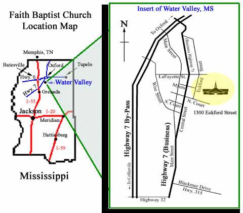
- At the first Traffic Light you meet, make a Left Turn onto North Court Street.
- Once on North Court Street, prepare for an immediate Left Turn at the first small street you meet. Eckford Street "T's" in from the left about a half block distance, just past a bank drive through.
- The church is the second building on the Right, just past the parsonage.
The U.S. 72 South exit is near Kimball, TN, and will head you towards Scottsboro, AL and Huntsville, AL. U.S. 72 is four lanes wide all the way across Alabama, and is generally divided by a grass medium.
Note: You will stay on U.S. 72 all the way across Alabama, exiting about five miles before the Mississippi state line in order to take theNatchez-Trace Parkway south towards Tupelo.
It is also possible to do a by-pass around the heart of town by taking a I-565 West to Highway 255 North route back to U.S. 72 West.
Coming into Athens, you will cross I-65 which runs from Birmingham, AL to Nashville, TN.
In Florence, AL, there are about three or four key turns which are all well marked. Coming into and leaving the Florence area takes some time, as the Florence city limits extends to both sides of the Tennessee River.
At this point, you will be heading for Cherokee, AL. Just outside of the small town of Cherokee (about 2 miles) you will find the entrance sign to the Natchez-Trace Parkway.
The trip on the Natchez-Trace Parkway, is 50 to 55 miles per hour, being a very scenic route. There are NO Trucks on the "Trace" as it is called. The trip takes an hour to the Tupleo exit at Highway 78.
This is also the exit for Sherman, MS. A sign will indicate that it is also for Oxford, MS. Exit to the right, then left under the overpass, heading south for about 10 miles.
Oxford is the home of the University of Mississippi, known as "Ole Miss."
Hwy. 76 is a 4 mile extension of Highway 6 which goes west to Oxford.
Bear to the RIGHT, staying with Hwy. 7 South.
The other route to the left is Hwy. 9W which you do NOT want.
At the last half mile, Highway 7 will widen into a divided 4 LANE.
This will place you onto Old Highway 7 (better known as Central Street).
The traffic light is just past a Shell Gas Station located on the on the right.
At this point, you may also choose to turn LEFT at the street BEFORE the Shell Station. Myers Street ends into our parking lot.